Clouds
There are many different types of cloud which can be identified visually in the atmosphere. These were first classified by Lamarck in 1802, and Howard in 1803 published a classification scheme which became the basis for modern cloud classification. The modern classification scheme used by the UK Met Office, with similar schemes used elsewhere, classifies clouds according to the altitude of cloud base, there being three altitude classes: low; mid level and high. Within each altitude class additional classifications are defined based on four basic types and combinations thereof. These types are Cirrus (meaning hair like), Stratus (meaning layer), Cumulus (meaning pile) and Nimbus (meaning rain producing). Each main classification may be further subdivided to provide a means of identifying the many variations which are observed in the atmosphere. The table below lists the standard classifications used by the UK Met Office and gives example images of each along with brief descriptions. Additional to these main types there are a few other types of cloud including noctilucent, polar stratospheric and orographic clouds. A few examples of some of these are given at the bottom of the table below. Often several types of cloud will be present at different levels of the atmosphere at the same time.
Table of Cloud Types
Low Level Cloud - Base is usually below 6,500ft
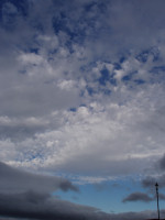
Cumulus
These clouds usually form at altitudes between 1,000 and 5,000ft, though often temperature rises after formation lead to an increase in cloud base height. These clouds are generally formed by air rising as a result of surface heating and may occasionally produce light showers.
Stratus
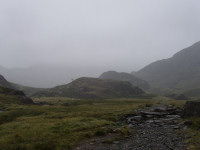
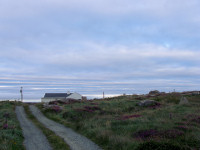
Usually forms between the surface and 2,000ft, but cloud base can be up to 4,000ft. Thick stratus can produce considerable precipitation, particularly in hilly or coastal regions, though in some cases this precipitation may be falling from higher clouds such as nimbostratus. While thick stratus will obscure the sun or moon, they are clearly visible through thin stratus.
Stratocumulus
This cloud often occurs at altitudes between 1,000 and 4,000ft, though sometimes may be higher. While not generally producing precipitation these clouds may produce drizzle, particularly in hilly or coastal areas, and may be thick enough to obscure the sun or moon. These clouds consist entirely of liquid drops and are often formed close to the top of the planetary boundary layer.
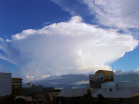
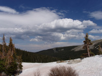
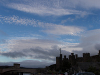
Cumulonimbus
Cloud base is typically between 2,000 and 5,000ft, though in some cases this may be lower or higher. These clouds are formed when conditions are such that deep convection is able to develop, and may have a huge vertical extent particularly in the tropics, sometimes reaching the tropopause. These clouds produce heavy showers, thunderstorms and hail, often also producing squally winds. At lower levels these clouds consist of liquid drops, but as altitude increases the cloud progresses through mixed phase and fully glaciated conditions. A fully developed cumulonimbus cloud may have a classic anvil appearance as the upper levels of the cloud spread out on reaching the tropopause. These systems may produce a considerable amount of cirrus cloud as the anvil spreads out.
Mid Level Clouds – Base is usually between 6,500ft and 20,000ft with some exceptions. Mid level clouds typically form at temperatures between 0 and –40C depending on altitude and season, so may consist of warm or supercooled droplets and ice particles.

Altostratus
Cloud base ranges between 10,000 and 20,000ft. Thicker forms of these clouds often produce continuous light precipitation and hide the sun or moon, though thinner forms show the sun or moon with a ground glass appearance.
Altocumulus
This type of cloud typically occurs between 6,500 and 20,000ft and is generally broken in appearance, though can occasionally produce precipitation and be thick enough to hide the sun or moon.
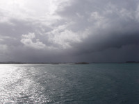
Nimbostratus
Cloud base ranges from the surface to 10,000ft. These clouds always hide the sun or moon, and normally produce continuous precipitation which is often moderate to heavy.
High Level Clouds – Base is usually above 20,000ft
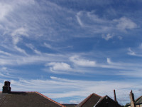
Cirrus
Base is typically between 20,000 and 40,000ft in the UK, and may be considerably higher in the tropics. Cirrus clouds do not produce precipitation which reaches the ground, though streaks of particles (known as fall streaks) are often observed below these clouds. Various halos and other optical effects may be produced by cirrus cloud. In some cases these clouds are also thick enough to hide the sun. Cirrus clouds typically form at temperatures below -40C and consist entirely of ice particles.
Cirrostratus
A thin high level layer cloud, which often produce halos and through which the outline of the sun is generally visible. These clouds are often the first visible indication of an approaching weather front, and may progressively thicken to altostratus and then nimbostratus with lowering of cloud base as the front approaches.
Cirrocumulus
Typically found in a similar altitude range to cirrus, these clouds do not produce precipitation and are usually more broken in appearance than cirrus, with the position of the sun or moon being visible.
Other Cloud Types
Orographic
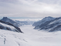
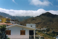
Formed as air is forced to rise over elevated terrain, cloud base is dependant on prevailing conditions, but is similar in range to that of other low level clouds. Orographic cloud is often in contact with the ground at the hill top. These clouds often do not produce precipitation, but larger systems may produce drizzle. Heavier rain is generally due to thicker cloud above. Orographic cloud may be liquid or ice depending on prevailing conditions and terrain altitude.
Noctilucent
Very thin cloud composed of water ice. These clouds are the highest clouds in the atmosphere, located in the mesosphere at an altitude of approximately 280,000ft. They are only visible when illuminated by light from below after the sun has gone below the horizon.
Polar Stratospheric
Thin cloud composed of ice particles located in the stratosphere in polar regions. This cloud may be at similar altitudes to cirrus cloud due to the lower height of the tropopause at the poles.
As is indicated in the above table different types of cloud are formed in different atmospheric conditions – temperature – humidity – dynamics – stability. From a microphysical point of view, clouds may be liquid, mixed phase, or ice and different microphysical processes are involved in each case.