CSIP-Convective Storm Initiation Project
Fieldwork

Fieldwork for CSIP consisted of a pilot project in June 2004, followed by a full intensive campaign from June to August 2005, with the pilot project being used to inform and optimise the use of equipment during the main campaign.
The work was centred around the Council for the Central Laboratory of the Research Councils (CCLRC) site at Chilbolton, on the eastern edge of Salisbury Plain (Goddard et al.; 1994, Naud et al., 2005). The two primary instruments mounted on the 25m radar dish at this site are the Chilbolton Advanced Meteorological Radar Antenna (CAMRA), which can identify boundary_layer structures such as thermals and cloud shapes, and also give wind and moisture fields, and ACROBAT - the Advanced Clear Air Radar for Observing the Boundary Layer and Troposphere.
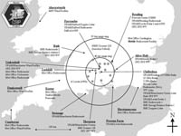
For CSIP, the radar measurements were supplemented with a UHF wind profiler, sodars and Doppler Lidars stationed at sites within the radar range, as well as a mesonet of automatic weather stations spaced at roughly 20km intervals. Radiosondes were launched at up to hourly intervals from six sites. The FGAM Cessna and IMK Dornier 128 were flown during selected conditions.
On any given day, the probability of the onset of convective precipitation was assessed by the use of the model early in the day, with a forecast available by 0900GMT. If suitable conditions were forecast, then the day would be declared an Intensive Operating Period (IOP).
The forecast was then also used to determine the optimum flight plan for the Cessna and Dornier aircraft. Three routes were pre-determined, based on the use of a number of navigational waypoints, although modifications were made on the day due to adverse weather (usually the presence of thunderstorms), or as a result of Air Traffic Controller instructions.