PUMA Project - Sample Results
Aircraft Profiles
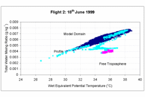
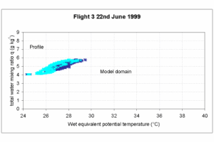
The figures below are Paluch diagrams showing characteristic thermodynamic properties of the urban boundary layer over the PUMA Model domain. Total water mixing ratio and wet equivalent potential temperature represent two conserved properties that can be used to determine mixing between different levels in the atmosphere. The results of 18th June show significant inhomogenity in the boundary layer but little mixing with the free troposphere above. The results of the 22nd June flight show the boundary layer is reasonably well mixed.
Aerosol Characteristics
Flight 2 on 18th June 1999: a very dry warm urban boundary layer was observed with two distinct regions above and below 900 mb.
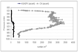
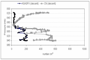
Profiles obtained in an unpolluted region upwind of Birmingham show marked changes in aerosol size distribution in the vertical. The figure shows low aerosol concentrations for sizes>100 nm (measured by an optical particle counter PMS-ASASPX) declining even further in the vertical below 900 mb whilst a second instrument (TSI 3010 CPC) showed a marked increase in aerosol concentrations for sizes >50 nm.
NOX concentrations also fell in line with the ASASPX concentrations.
A subsequent descent showed good agreement in the trends between the two aerosol size ranges although a marked increase in aerosol >50 nm is again observed at higher levels.
Pollution Characteristics
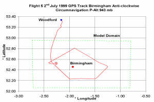
The figure below shows a typical flight track within the PUMA Model domain centred on Birmingham where simultaneous measurements of trace gas and aerosol constituents were being made.
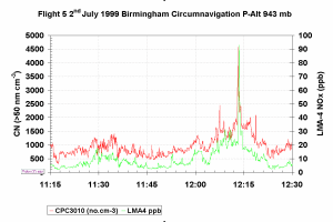
The time series graph shows the concentrations of NOx and total aerosol (> 50 nm) measured at constant altitude around Birmingham. The large broad plume is from the general area sources comprising the Birmingham conurbation whereas the spike is from the point source of a power station.
City Scale Fluxes
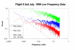
One objective of the PUMA aircraft component was to attempt to estimate net fluxes within the boundary layer by combining turbulence data with fast response gas and aerosol measurements. The power spectra shown above are based on the aircraft on-line block averaged time series (0.5 Hz).
The black line shows the expected “-5/3" spectral response for a continuous turbulence field. Departures from the ideal are due to different source and sink mechanisms for the different gases e.g. note the departure in the low frequency behaviour of ozone compared to that for NOx.