SAMBBA - South AMerican Biomass Burning Analysis
The SAMBBA project aims to investigate the properties of biomass burning pollution over South America. The pollution from biomass burning can have a substantial impact upon human health, as well as perturbing regional weather and climate through the emission of high concentrations of aerosol particles containing organic matter and black carbon. The effects of atmospheric aerosols on climate are very significant but extremely uncertain and so developing our understanding of them is crucial for predictions of future climate change.
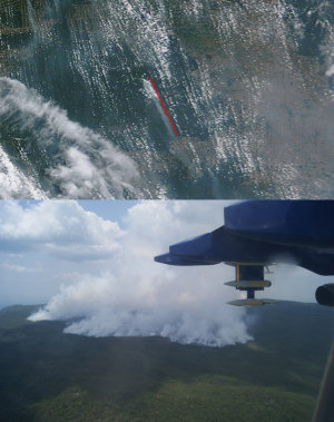
SAMBBA is an international consortium of 7 UK universities, the UK Met Office, InstitutoNacional de PesquisasEspaciais(INPE, Brazilian National Institute For Space Research) and the University of São Paulo. SAMBBA combined advanced ground, aircraft and satellite measurements during an intensive field campaign during September/October 2012. A total of 20 science flights were conducted on the UK Facility for Airborne Atmospheric Measurement (FAAM) BAe-146 research aircraft during the campaign. The aircraft was based in Porto Velho, the capital of Rondonia, where ground-based measurements were also conducted by the University of Sao Paulo.
The flights sampled a huge range of pollution conditions, ranging from extremely low concentrations of gas phase and aerosol species over the pristine Amazon rainforest, through to huge fire plumes emitting massive amounts of pollutants. The flights were often coordinated with satellites overpassing the flight track of the aircraft, which allowed us to combine our intensive measurements with those that occur routinely from space (see Fig. 1). A range of numerical models are also to be used during SAMBBA, which will help to put our measurements into context and they will also be improved by the measurements that were made during the campaign.
These measurements will be used to improve our understanding of biomass burning emissions and how it evolves in the atmosphere. This knowledge will help us to challenge and improve numerical models and satellite retrievals in the future. Such knowledge will advance our ability to predict the impacts of biomass burning on human health, the Amazonian biosphere and on weather and climate.