TROSIAD - TROpopause folding, Stratospheric Intrusions And Deep convection
Introduction
TROSIAD (TRO-shad, with the 'tro' as in 'trough') is Welsh for "conversion." The goal of the TROSIAD project is to "convert" observed weather data to a climatology, "convert" field research data to idealized modeling simulations, and "convert" our research results to knowledge useful to operational forecasters.
This project uses a combination of: (i) analysis of archived ozonesonde and VHF radar profiles; (ii) detailed case studies of a spectrum of events; and (iii) modelling a sample of these events using a weather forecasting model. The goal is to build a conceptual model linking tropopause folds and tropopause-level cyclonic anomalies to the occurrence of deep convection, that may be used by operational meteorologists to improve weather forecasts.
Overview
Deep convection brings heavy rain, flooding, strong winds and fire risk from lightning. Forecasting these events accurately is therefore a priority for meteorologists. Deep convective storms have many causes, some of which are relatively easy to predict, but others of which are more subtle and not well understood.
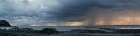
One example of the latter is the effect of stratospheric intrusions and layers of stratospheric air on the development of convection. The processes by which weather systems form involves distortions of the tropopause, bringing stratospheric air to altitudes normally found in the troposphere. It has long been known that these intrusions promote convection, by destabilizing the environment and providing forcing for ascent, but recent research has suggested a more complex picture is possible, with convection in some cases being suppressed by the stable layers associated with the intrusions.
The picture gets even more complex when the evolution of these stratospheric intrusions is considered–layers of stratospheric air flow into the troposphere and become detached from their parent trough, travelling many thousands of miles before dissipating. In most cases such layers inhibit convection, but in certain circumstances they appear to initiate lines of thunderstorms. This project seeks to clarify the overall impact of stratospheric intrusions and layers on convection.
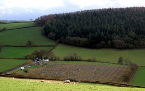
The project uses a combination of statistical studies using past data, dedicated case studies and numerical modelling. Two novel datasets not applied to convection research previously will be exploited in the statistical studies–the database of European ozonesonde profiles gathered since 1990 and the NERC MST radar which has operated continuously since 1996. From the radar data we will learn about the vertical structure of tropopause-level disturbances and their associated convection, and from the ozonesondes we will learn how frequently layers that can affect convection and are of stratospheric origin are measured.
These will provide context for the next stage of the project, which is to conduct a series of case studies (5-6 cases), using the MST radar together with lidars to measure ozone and water vapour. We seek cases that span the continuum from tropopause-level disturbances through tropopause folds to detached layers, where convection has occurred and where it has not. Satellite data and rain radar data from the Met Office (available from BADC) will provide the observations of convection for these case studies. Measurements will be compared with ECMWF and UM analyses to determine how well the convection was represented in the models.The case studies will be used to guide a series of numerical modelling experiments based on the WRF model, to pinpoint the physical processes involved in the interaction between stratospheric intrusions and layers on the one hand and convection on the other. Questions to be addressed will include the mechanism whereby bands of showers form at the leading edge of stratospheric layers (is this merely a coincidence?), the initiation of convection by stratospheric intrusions (is this just a misnomer?) and the transition between convective initiation and suppression as a layer evolves. By changing the initial conditions in the model and rerunning the model, we will be able to understand the sensitivity of the resulting convection to the stratospheric layers. The results from the project will inform weather forecasters of the importance of representing stratospheric features correctly for convection forecasting, and bring a rather disparate area of the scientific literature to a focus.
Project Summary
The project is split into three working packages:
Work Package I - Occurrence of stratospheric layers and convection
Tropopause folds have been shown to enhance or inhibit convective storms, but how does a forecaster know which will happen in any given situation? How does the structure of tropopause folds affect the occurrence, location and morphology of convection?
As a start to answering these questions, we have developed a five-year (2006–2010) radar-based climatology of tropopause folds and convective storms for Wales. Based on the continuous, high-resolution data from the NERC MST radar, 183 tropopause folds were identified. A maximum of tropopause-fold cases occurred in January with a secondary maximum in July. Based on the data from the weather radar network operated by the UK Met Office, a radar-based climatology of convective storms was developed, resulting in 685 cases. Convective storms are associated with approximately 50% of the tropopause folds identified in this study. Unlike much of the US where a clear annual cycle peaking in the warm season occurs, convective storms over Wales display a relatively consistent occurrence throughout the year, except for a strong minimum in late winter and early spring.
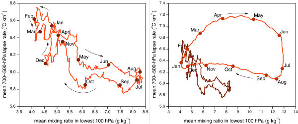
The tropopause folds were then classified according to their location with respect to an upper-level trough into four categories: east of the trough, underneath the tropopause fold on eastern side of the trough, underneath the trough and underneath the fold on the western side of the trough. Of the tropopause folds observed on the eastern side of an upper-level trough, approximately 70% were associated with convective storms, most commonly in the form of multicellular lines. Of the tropopause folds observed on the western side of an upper-level trough, approximately 30% were associated with convective storms, most commonly isolated cells. These results show that the stronger the synoptic forcing, the more likely storms are to be more highly organized.
Work Package II - Case studies of stratospheric layers and convection
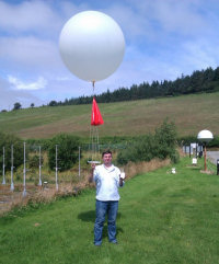
Three measurement campaigns have been conducted for TROSIAD, in September and November–December 2011, and in July–August 2012 resulting in approximately 10 intensive observation periods (IOPs). Field campaigns were conducted with the objective of obtaining case studies that will improved our understanding of the physical mechanisms linking tropopause folds and convective storms. The observations coordinated with the DIAMET project included the following activities: radiosonde observations, MST radar, and aircraft measurements.
Work Package III - Modelling and sensitivity studies of stratospheric layers and convective storms
The final working package of the project will involve idealized numerical modelling experiments based on the WRF model in order to identify the physical processes controlling the interaction between stratospheric layers and convective storms.
Interaction with users and dissemination
Participation at the Cyclone Week an event organized by the EUMeTrain between 4 and 6 June 2012, consisting of several sessions given by different institutes. Approximately 60 forecasters attended the online seminars.
Recent publications
Antonescu, B., G. Vaughan, and D. M. Schultz, 2013: A five-year radar-based climatology of tropopause folds and deep convection over Wales, United Kingdom. Mon. Wea. Rev., in press. [abstract]
Recent conference presentations
Antonescu, B., G. Vaughan, and D. M. Schultz, 2012: A radar-based climatology of tropopause folds and deep convection. 26th Conference on Severe Local Storms, 5–8 November, Nashville, TN. [abstract]
Antonescu, B., G. Vaughan, and D. M. Schultz, 2012: Is tropopause folding promoting or suppressing deep convection? First results from TROSIAD. EGU General Assembly, 22–27 April, Vienna, Austria., p.8948. [abstract]
Project Details and Further Information
The research project builds on research at the University of Manchester and other UK institutions during recent field programs to study convection in the UK and Europe. Relevant publications are listed above. The project is funded by NERC and will last for three years, starting in September 2010. The project Principal Investigator is Prof. Geraint Vaughan, the co-Investigator is Prof. David M. Schultz, and Dr. Bogdan Antonescu is the PDRA. For more information, please contact us directly.