Remote Sensing
The group's work is concerned with composition, transport and dynamics in the atmosphere from the ground to the lower stratosphere. The group's work concerns both measurements and theoretical interpretation, and is based on a range of experimental facilities available at Manchester and elsewhere throughout the world. There is close interaction with other aspects of the Atmospheric Science research in SEAES and with other groups in the National Centre for Atmospheric Science (NCAS)
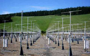
The Mesosphere-Stratosphere-Troposphere (MST) VHF radar is a UK national facility located near Aberystwyth, mid-Wales. This impressive phased-array radar with 400 antennae is used to study winds, atmospheric gravity waves and turbulence from near the Earth's surface to an altitude of 90 km.The site also houses campaigns by a UHF (1290 MHz) radar which measures winds in the lowest 3 km, and which is mounted on a trailer for easy transport to other locations for field campaigns. This is part of NCAS’s Facility for Ground-Based Atmospheric Measurements (FGAM). Currently, the two radars are being used to study the properties of frontal passages over the radar, the occurrence of extreme winds in the lower troposphere, the relationship between tropopause folding and deep convection and the diurnal growth and decay of the planetary boundary layer.
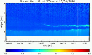
Co-located with the MST radar is a similar facility, but using light rather than radio waves. These laser radars, or lidars, measure the distribution of water vapour, ozone and aerosols in the troposphere and lower stratosphere. This lidar facility is the most versatile of its type in the UK, and, because of the excellent vertical resolution offered by the lidar technique it provides a uniquely powerful tool for studying transport and dynamics in the atmosphere. With it, we can measure water vapour, aerosols and clouds in the atmosphere. During the volcanic ash emergency of 2010, for example, our lidars provided vital information to the Met Office on the location and thickness of ash layers which helped them forecast where and when aircraft could fly safely.
The group also hosts FGAM’s mobile 5-wavelength lidar which is designed to study aerosol and ozone in the boundary layer. It is particularly suited to pollution studies, and was recently deployed at the Rutherford Appleton Laboratory as part of the Clean Air for London (ClearfLo) project.
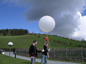
Long-term monitoring of the thickness of the ozone layer is conducted with a zenith-sky diode-array SAOZ spectrometer. This instrument also monitors nitrogen dioxide and polar stratospheric clouds. We also operate a radiosonde RS90-AG system for measuring temperature, humidity, pressure and wind speed from small balloon packages, as well as ozonesondes to measure ozone profiles.
Recent campaigns in which the group has participated include the COPS project in the Black Forest in 2008, the TURBOT and THAW projects to study atmospheric turbulence at Capel Dewi in 2009-10, the DIAMET and ClearfLo projects in 2011-12 and the TROSIAD project, also at Capel Dewi in 2011-12.
Recent papers:
N. J. King and G. Vaughan. Using passive remote sensing to retrieve the vertical variation of cloud droplet size in marine stratocumulus: an assessment of information content and the potential for improved retrievals from hyperspectral measurements. J. Geophys. Res., 117, D15206, doi:10.1029/2012JD017896, 2012.
A. Russell, G. Vaughan and E. G. Norton. Large scale potential vorticity anomalies and deep convection. Quart. J. Roy. Meteorol. Soc., published online 23 Jan 2012. DOI: 10.1002/qj.1875.
J. Lawson, G. Vaughan and D. M. Schultz. Classifying Fronts in Data from a VHF Wind-Profiling Radar. Atmos. Sci. Let., 12, 375–380, 2011. DOI: 10.1002/asl.353
B. J. Devenish, D. J. Thomson, F. Marenco, S. J. Leadbetter, H. Ricketts, H. F. Dacre.
A study of the arrival over the United Kingdom in April 2010 of the Eyjafjallajokull ash cloud using ground-based lidar and numerical simulations.
Atmos. Environ., 48, 152-164, 2012.
X. V. Francis, C. Chemel, R. S. Sokhi, E. G. Norton, H. M. A. Ricketts, B. E. A. Fisher.
Mechanisms responsible for the build-up of ozone over South East England during the August 2003 heatwave. Atmos. Environ., 45, 6880-6890, 2011.
F. Marenco, B. Johnson, K. Turnbull, S. Newman, J. Haywood, H. Webster, H. Ricketts.
Airborne lidar observations of the 2010 Eyjafjallajokull volcanic ash plume.
J. Geophys. Res., 116, art. no. D00U05, 2011.
G.Parton, A. Dore and G. Vaughan. A climatology of mid-tropospheric mesoscale strong wind events as observed by the MST Radar, Aberystwyth. Met. Apps. 17, 340-354, DOI: 10.1002/met.203, 2010.
G. A. Parton, G. Vaughan, E. G. Norton, K. A. Browning and P. A. Clark. Wind profiler observations of a sting jet. Quart. J. Roy. Meteorol. Soc. 135, 663-680, 2009.
A. Russell, G. Vaughan, E. G. Norton, H. M. A. Ricketts, C. J. Morcrette, T. J. Hewison, K. A. Browning, A. M. Blyth. Convection forced by a descending dry layer and low-level moist convergence.
Tellus Series A-Dynamic Meteorology And Oceanography, 61, 250-263, 2009.