Holme Moss PROCLOUD Project
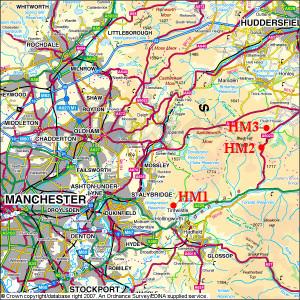
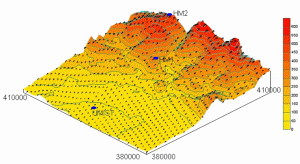
Holme Moss measurement sites
Upwind site looking towards Holme Moss.
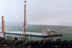
Holme Moss summit, with met station and cloud instrumentation.
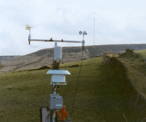
Downwind met station, looking towards the summit.
Introduction
The aim of Holme Moss PROCLOUD experiment was to investigate interactions of the Manchester urban plume with a hill cap cloud which forms at the summit of Holme Moss. This experiment was designed to study conditions which contrasted with the earlier series of hill cap cloud experiments at Great Dun Fell in clean conditions, and the ACE-2 hillcloud project carried out in 1997 on Tenerife where a mixture of clean and very aged polluted conditions were studied. At Holme Moss, pollution just a few hours downwind of the source region was sampled (compared with several days during ACE-2). During the Holme Moss project relationships between upwind aerosol and trace gas properties, cloud microphysical properties, and the effects of cloud on the evolution of an urban plume were studied. The experiment had the following specific scientific objectives:
- To investigate the interaction of the Manchester urban plume with the hill cap cloud which forms at the summit site.
- To examine the effects of the properties of the aerosol and trace gases in the airmass flowing into the cloud on the microphysics and chemistry of the cloud.
- To investigate the role of the cloud in modifying the properties of the aerosol and trace gases emerging downwind of the cloud system.
- To investigate the evolution of the urban plume.
This project was carried out as an international collaboration involving groups from The University of Manchester, Division Nuclear Physics, Lund University, Sweden, Institute of Experimental Physics (IEP), University of Vienna, Austria. and Institute for Tropospheric Research (IFT), Leipzig, Germany.
Project Description
The Holme Moss PROCLOUD project was carried out during March 1999 in the Southern Pennines, east of Manchester. Four measurement sites were used during the project. These were located at UMIST in city centre Manchester, Hollingworth Hall Farm in Mottram, Holme Moss summit, and Holme village. These sites were referred to as Manchester, HM1, HM2, and HM3 respectively. In the prevailing westerly winds, Manchester and HM1 were upwind sites, and HM3 was downwind. Sites HM1 and HM3 were temporary sites established for the PROCLOUD measurements, at Manchester and HM2 although some long-term monitoring activities were also carried out significant additional instrumentation was deployed for the PROCLOUD measurement period. Sites HM1 and HM3 were powered by generators and precautions were taken with the siting of these generators, and the provision of exhaust extensions, to reduce the possibility of site contamination by generator exhaust. However, in some wind directions it was clear that exhaust from the generators was being detected. These wind directions were not those of most interest for the experiment, and such conditions occurred infrequently.
Holme Moss measurement sites
Site |
Height |
Lat. |
Long. |
Manchester |
50 |
53.48 |
-2.23 |
Hollingworth Hall Farm (HM1) |
308 |
53.48 |
-1.99 |
Holme Moss Transmitter (HM3) |
525 |
53.53 |
-1.86 |
Cliffe Rd., Holme (HM3) |
370 |
53.55 |
-1.85 |
From the map shown it can be seen that there is a significant distance between the main upwind site at HM1 and the other sites. This was not ideal, but was unavoidable due to the shape of Holme Moss, and the desire that the upwind site remain out of cloud. Most of the land between HM1 and HM2 was rather too high and so would be much more likely to go into cloud. Other possible upwind sites were unsuitable because of inaccessibility. The distance between HM1 and the other sites, and also the somewhat sheltered location of HM1 caused some additional problems of dilution between the sites, and disconnection of HM1. Additional care was taken during data analysis to ensure that conclusions were drawn only from time periods where it could be shown that there was connected flow between all three sites.
At HM1 and HM3 detailed measurements were made of aerosol properties, including size distribution (also at Manchester), chemical composition, and solubility (HM1 only). Major gas species were measured at HM1 and HM2. Cloud microphysics and chemistry, as well as interstitial aerosol were measured at HM2. Meteorological conditions were measured at all sites. Data was also available for the period of the project from long-term measurement sites not connected to the Holme Moss project, in Manchester City Centre (air quality, including major gases and particulates) and Aberporth in North Wales (sonde ascents).
Experiment protocol
Many instruments were operated continuously throughout the whole measurement period from the 1st - 31st March, with most continuous measurements being available from 11th March. Some instruments including impactors and cloud instruments were only operated when cloud was present at the summit site. These periods of time, where all equipment was running, were designated as intensive run periods and are listed in the table below. This table also notes any major measurements which were missing during intensive run periods.
Run |
Date |
Times |
Comments |
1 |
12/3/99 |
00:00-07:30 |
UW DMPS missing |
2 |
16/3/99 |
05:30-12:30 |
HM1 not connected |
3 |
17/3/99 |
05:00-10:00 |
HM1 not connected, No DAA data |
4 |
18/3/99 |
04:00-06:30 |
|
5 |
(20-21)/3/99 |
23:00-07:00 |
No DAA data |
6 |
23/3/99 |
01:00-15:00 |
FSSP missing after power cut |
6.5 |
24/3/99 |
05:00-08:00 |
FSSP missing, No DAA data |
7 |
25/3/99 |
12:00-21:00 |
FSSP missing, No DAA data |